Explore
Featured
Recent
Articles
Topics
Login
Upload
Featured
Recent
Articles
Topics
Login
Upload
Search Results for 'marine data'
marine data published presentations and documents on DocSlides.
Ocean Data Interoperability Platform (ODIP): developing a common framework for marine data manageme
by cheeserv
scale. Helen Glaves. 1. and Dick Schaap. 2. 1 Bri...
Marine Bird surveys
by tatiana-dople
Collecting data to identify important areas for b...
Regional marine spatial planning
by briana-ranney
- the Shetland experience. Rachel . Shucksmith. M...
INSPIRE Marine Pilot
by tatiana-dople
Progress & status. November 2015. Outline. Ma...
SEA MARINE SCIENTIFIC RESEARCH
by belinda
22March 2016DEEP-AND GENETIC RESOURCESIN AREAS BEY...
East coast marine mammal acoustic study: using multiple mod
by marina-yarberry
harbour. porpoises and bottlenose dolphins. K.J....
Using AIS to inform Marine Spatial Planning
by tawny-fly
and marine industries. Richard L. Shelmerdine. a...
Engaging Students with an OOI Ocean Data Lab Focused on Factors that Affect Primary Productivity
by joanne
Jean R. Anastasia. Suffolk County Community Colleg...
Ocean Data Interoperability Platform (ODIP): developing a c
by alida-meadow
scale. Helen Glaves. 1. and Dick Schaap. 2. 1 Br...
Regional Hydrographic Commission Report to IRCC10
by joyce
Norwegian Hydrographic Service. Norwegian . Mappin...
CMEMS in situ TAC Copernicus Marine Environment Monitoring Service
by heartfang
in situ Thematic . Assembly . Centre . A service f...
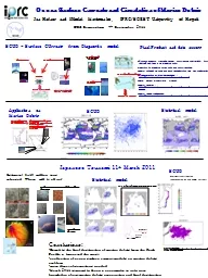
MEDSLIK oil slick simulation
by provingintel
Sea Surface Temperature Dashboard. Forecast of sea...
Deliverable 1.1 „ Determination
by mentegor
. of. . the. GES in . the. . Mediterranean. , ....
Marine Geospatial
by karlyn-bohler
Ecology Tools. Jason Roberts, Ben Best, Dan Dunn,...
Global characteristics of marine
by ellena-manuel
stratocumulus clouds and . drizzle. Sandra . Yute...
BGS MEDIN DAC for Geology, Geophysics & Backscatter
by tawny-fly
Mary . Mowat. BGS Marine Data and Information. mm...
Marine Geospatial
by celsa-spraggs
Ecology Tools. Jason Roberts, Ben Best, Dan Dunn,...
UK CME PROGRAMME 16 November 2019
by beatrice
What is the CME Programme?. 2. UK Government Funde...
x0000x0000UNEPDEPIMED IG22Page Decision IG227
by pagi
Integrated Monitoring and Assessment Programme of ...
SESSION 1 Levels of depredation and trends in Toothfish fisheries.
by eatsui
Eduardo Infante, AOBAC, Chile. History of the Fish...
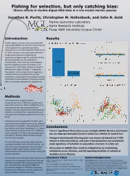
Jonathan B. Puritz, Christopher M. Hollenbeck, and John R. Gold
by blindnessinfluenced
Fishing for selection, but only catching bias: . l...
ANNOUNCEMENT To Register
by ellena-manuel
for the Monthly Disease . Surveillance Trainings:...
Small scale reflection seismology
by ellena-manuel
CMP gather. 3D seismic reflection. The goal is a ...
Offshore Seismic and the Regulatory Tidal Wave
by aaron
Shawn . L. Rice. Board of Directors, IAGC. NOIA A...
Synthesis of Arctic Research (SOAR)
by debby-jeon
Sue Moore, NOAA/NMFS. Phyllis Stabeno, NOAA/OAR. ...
Beach Energy Ltd
by phoebe-click
Lake Tanganyika 2D Transition Zone Seismic Survey...
Empirical
by alexa-scheidler
Investigation . of the . Factors . I. nfluencing ...
Marine monitoring and Natural England
by liane-varnes
Gavin Black. Specialist . Marine . Monitoring. Ga...
¼ degree surface currents maps: daily from 01Aug1999 till
by test
Switch to ASCAT wind data for daily updates. SCU...
Beach Energy Ltd
by tatiana-dople
Lake Tanganyika 2D Transition Zone Seismic Survey...
iMarine: Accessing and Managing Biodiversity Data
by nonhurmer
Pasquale Pagano (CNR). iMarine Technical Director....
iMarine: Accessing and Managing Biodiversity Data
by reportcetic
Pasquale Pagano (CNR). iMarine Technical Director....
FCWC-FIRMS workshop on fisheries inventories
by ahmad994
<Name of the Author>. Rel. to agenda item 5:...
Collaborative scientific platforms for accessing, processing and validation of
by audrey
biodiversity observation . and biosensor data. . F...
The CarbonNet Project POSTER B
by wang
CarbonNet storage concepts. CarbonNet has shortlis...
River Information Services Enterprise (RISE)
by oneill
Trabus Technologies. 3547 Camino Del Rio South, Su...
AI/ML Discussion TECOM Warfighting Club
by TravelingSoulmate
27 Nov 2018. Caveats . (and the state of USMC A...
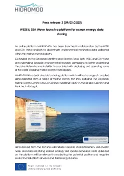
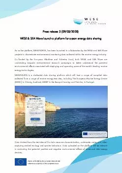
Project co
by amey
-funded by the European Maritime and Fisheries Fun...
Project co
by bethany
- funded by the European Maritime and Fisheries F...
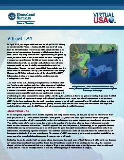
In April 2010 the largest accidental marine oil spill in US history
by candy
TM Through Virtual USA, Virtual Louisiana shares d...
Load More...